Rivers in India played a crucial part in shaping Indian civilisation from ancient times to the present day. These vital waterways have transformed human existence, moulded societies, given birth to magnificent cities, and significantly contributed to the overall nation’s development.
In this comprehensive article, we will explore the major rivers in India, examine their numerous tributaries, and develop a thorough understanding of the distinct river systems that characterise each waterway.
Classification of Indian Rivers
Rivers in India are systematically divided into four major groups based on their geographical origin, distinctive characteristics, and the diverse regions through which they flow.
Himalayan Rivers
These rivers originate from the Himalayan Mountain ranges and are fed by both monsoon rains and glacial melt, ensuring year-round water flow
E.g.: – Ganga, Indus and Brahmaputra
Deccan Rivers (Peninsular) Rivers
These rivers flow through the Deccan Plateau and are primarily dependent on monsoon rainfall, making them seasonal in nature.
E.g.: – Godavari, Krishna, Kaveri, Narmada, Tapti
Coastal Rivers
These shorter rivers flow directly into the sea and are found along India’s extensive coastline, draining smaller catchment areas.
E.g.: – Mandovi, Zuari, Periyar, Netravathi
Rivers of the Inland Drainage Basin
These rivers do not reach the sea but drain into inland lakes or disappear into desert sands, primarily found in Rajasthan and parts of Haryana.
E.g.: – Luni River, Ghaggar-Hakra, Machhu River and Banas River
Major Rivers of India – Detailed Information
| River Name | Length (km) | Origin Place | End Place | Passes Through |
|---|---|---|---|---|
| Ganges | 2,525 | Gangotri Glacier, Uttarakhand | Bay of Bengal, West Bengal | Uttarakhand, Uttar Pradesh, Bihar, Jharkhand, West Bengal |
| Brahmaputra | 2,900 (916 in India) | Angsi Glacier, Tibet | Bay of Bengal (via Bangladesh) | Arunachal Pradesh, Assam |
| Yamuna | 1,376 | Yamunotri Glacier, Uttarakhand | Ganges at Allahabad, Uttar Pradesh | Uttarakhand, Himachal Pradesh, Haryana, Delhi, Uttar Pradesh |
| Godavari | 1,465 | Trimbakeshwar, Maharashtra | Bay of Bengal, Andhra Pradesh | Maharashtra, Telangana, Andhra Pradesh, Chhattisgarh, Odisha |
| Krishna | 1,400 | Mahabaleshwar, Maharashtra | Bay of Bengal, Andhra Pradesh | Maharashtra, Karnataka, Telangana, Andhra Pradesh |
| Narmada | 1,312 | Amarkantak, Madhya Pradesh | Arabian Sea, Gujarat | Madhya Pradesh, Gujarat, Maharashtra |
| Mahanadi | 858 | Sihawa Hills in Chhattisgarh | Bay of Bengal, Odisha | Chhattisgarh and Odisha |
| Kaveri | 800 | Talakaveri, Brahmagiri hills, Karnataka | Bay of Bengal, Tamil Nadu | Karnataka, Tamil Nadu |
| Tapti | 724 | Multai, Madhya Pradesh | Arabian Sea, Gujarat | Madhya Pradesh, Maharashtra, Gujarat |
| Indus | 3,180 (1,114 in India) | Mansarovar Lake, Tibet | Arabian Sea, Pakistan | Ladakh, Himachal Pradesh |
1. Ganges – The Longest River of India

The sacred River Ganges stands as India’s longest river, carrying immense economic, cultural, and historical significance throughout the subcontinent. Serving as a vital lifeline, it provides essential water resources for millions of people across northern India.
Culturally, the Ganges holds profound religious importance and is revered as one of the most sacred rivers for Hindus.
Flowing through numerous states across northern India, it fuels agricultural productivity, supports diverse industrial activities, and facilitates tourism. Making it a crucial driver of economic development across northern India.
Geography: Originates from Gangotri Glacier in Uttarakhand, flows 2,525 km before merging with the Bay of Bengal
Basin: Covers about 26% of India’s landmass, supporting over 500 million people
Cultural Significance: The Most sacred river in Hinduism. Major pilgrimage sites include Haridwar, Rishikesh, Varanasi, and Prayagraj. Famous events like Ganga Aarti and Kumbh Mela are held at the confluences of this river.
Major Dams & Power Projects: Tehri Dam (Uttarakhand), Farakka Barrage (West Bengal), Bansagar Dam, and several hydroelectric projects in the upper reaches
Tributaries: Major tributaries include the Yamuna, Gandak, Kosi, Gomti, and Chambal
Economic Importance: Supports agriculture through the fertile Gangetic plains, inland navigation, and the fishing industry. 40% of the country’s GDP comes from this region
Key Issues: The river faces severe pollution issues. Namami Gange program launched for river cleaning
2. Brahmaputra
The mighty River Brahmaputra flows through northeastern India, originating from Tibet and merges with the Ganges.
This powerful river supports extensive agriculture, particularly rice cultivation.
Culturally, it holds deep significance for Assamese people and other northeastern communities, featuring prominently in their folklore and traditions.
The Brahmaputra is one of the few rivers in India that carries a masculine name, unlike most Indian rivers, which are given feminine names. The word “Brahmaputra” literally translates to “son of Brahma,” referring to the Hindu creator god, highlighting its revered status in Indian mythology and culture.
Geography: Total length 2,900 km (916 km in India), flows through Tibet, India, and Bangladesh
Unique Features: Home to the world’s largest river island (Majuli)
Cultural Significance: Sacred to Assamese culture. The festival Ambubachi Mela is held annually at the Kamakhya Temple in Guwahati. Traditional boat races and festivals like Bihu are celebrated along its banks
Major Dams & Power Projects: Lower Subansiri Hydroelectric Project, Ranganadi Dam, planned Dibang Multipurpose Project
Flooding: Known for annual floods that both devastate and fertilise Assam’s plains
Biodiversity: Supports a rich ecosystem, including Gangetic dolphins, various fish species, and riverine forests
Strategic Importance: Huge Hydroelectric generation capability, an international river with geopolitical significance.
Key Issues: The Brahmaputra is a source of potential conflict between India and China, as India alleges that China’s upstream dam construction could disrupt the river’s flow into Indian territory.
The river’s strategic importance heightens concerns about water resources and bilateral relations in the region.
3. Yamuna
River Yamuna is one of India’s most significant rivers, originating from the Bandarpunch range in Uttarakhand and flowing through Uttar Pradesh, passing cities like Delhi, Agra, and Firozabad.
As a major tributary of the Ganga, it holds great spiritual importance.
Recently, efforts to clean and rejuvenate the river have gained momentum, with projects aimed at reducing pollution and improving water quality.
It is a vital river that provides irrigation and water supply for industries and the public in and around Delhi, as well as for other major cities like Agra, Firozabad, and Etawah.
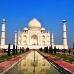
One of its specialities is the iconic Taj Mahal, which rests on its banks.
Geography: Originates from the Yamunotri Glacier, and travels a total length of 1,376 km
Historical Cities: Flows through Delhi, Agra, Mathura, and Vrindavan
Cultural Significance: This river holds sacred significance in Hinduism, with Major temples dedicated to Lord Krishna located in Mathura and Vrindavan on its banks. Hosts the famous Yamuna Chhath festival
Major Dams & Power Projects: Lakhwar Dam, Tajewala Barrage, Okhla Barrage, and Delhi’s Wazirabad Barrage
Agricultural Importance: Provides irrigation facilities for the fertile Indo-Gangetic plains, especially in the states of Haryana and Uttar Pradesh.
Key Issues: Severely polluted river, especially near Delhi. As part of the Namami Gange Programme, the Government of India has implemented various cleaning initiatives to clean up this river.
Water Disputes: The River Yamuna has been at the centre of a prolonged conflict between Delhi and Haryana, with Delhi accusing Haryana of polluting the river by discharging untreated sewage and industrial waste.
Furthermore, the two states are also entangled in an ongoing dispute over water sharing. Despite interventions by the Supreme Court in 1995 and 1996, the issues related to the river remain unresolved.
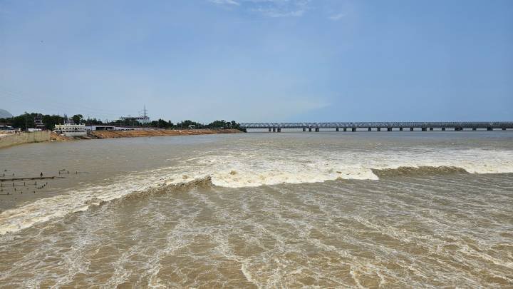
4. Godavari – Second Longest River In India
Popularly known as the ‘Ganaga of South’, the River Godavari is a vital waterway for the three states of Maharashtra, Andhra Pradesh, and Telangana. It is one of India’s longest peninsular rivers, traversing 1,465 km
Culturally, Godavari is home to numerous historic temples, making it one of India’s sacred rivers.
Additionally, it features impressive architectural landmarks, including iconic railway bridges and hydroelectric dams, enhancing its appeal as a tourist destination.
Its rich heritage and economic importance make the Godavari an integral part of South India’s landscape.
Geography: 1,465 km, the longest peninsular river of India, known as “Ganga of the South”. Originates in Maharashtra and Merges into the Bay of Bengal through Andhra Pradesh
Historical Cities: Nashik, Nanded, Rajamundry and Bhadrachalam
Cultural Significance: Seat to sacred pilgrimage sites like Nashik, Basara and Bhadrachalam temple.
Major Dams & Power Projects: Jayakwadi Dam, Sriram Sagar Project, Polavaram Project, Kaleshwaram Lift Irrigation Project and Dowleswaram Barrage
Agricultural Importance: Provides crucial irrigation support across three states, Maharashtra, Telangana, and Andhra Pradesh. It serves as a vital lifeline for agricultural development, particularly in the East and West Godavari districts of Andhra Pradesh, where farming communities depend heavily on its waters for Paddy and coconut plantations.
Industrial Corridor: Serves as a vital resource driving industrial development in Maharashtra, particularly supplying water to numerous automobile manufacturing plants in the Nashik and Aurangabad regions.
It also serves as the economic backbone of Rajahmundry, supporting its role as a major commercial centre for agricultural trade, wholesale markets, and retail businesses.
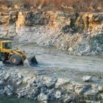
Key Issues: The river Godavari faces several pressing issues, including illegal sand mining, discharge of untreated industrial wastewater, extensive dam construction that disrupts natural flow patterns, and high agricultural runoff containing harmful fertilisers and pesticides.
5. Krishna – Lifeline of Deccan
River Krishna is the third longest peninsular river in India. It originates in the Western Ghats near Mahabaleshwar in Maharashtra and travels through Karnataka, Telangana, and Andhra Pradesh.
It is famous for its principal tributary rivers, Tungabhadra, Bhima, Malaprabha and Ghataprabha.
Geography: The Krishna River originates in Maharashtra’s Western Ghats and flows 1,400 km through Karnataka, Telangana, and Andhra Pradesh before reaching the Bay of Bengal, forming one of India’s largest interstate rivers and one of the most fertile river basins.
Historical Cities: Cities such as Vijayawada, Amaravati, and Srisailam developed into thriving trade hubs, spiritual centres, and governance centres.
Cultural Significance: Hindu mythology reveres the River Krishna as sacred; it is mentioned in the Mahabharata and several Puranas.
Sacred pilgrimage centres such as Srisailam, Amaravati, and Sangameshwaram are located in its banks.
Major Dams and Power Projects: The Krishna River is home to major hydroelectric projects like Nagarjuna Sagar, Srisailam, and Almatti dams, providing vital power and water supply that drive development across Andhra Pradesh, Telangana and Karnataka
Agricultural Importance: The Krishna basin is one of the most fertile basins in India, providing extensive agricultural support for the cultivation of paddy, Banana, Sugarcane, cotton, maize, pulses, groundnut, and Millets.
Industrial Importance: It acts as a vital source for industries across Karnataka, Andhra Pradesh, Maharashtra and Telangana.
It is a major water resource for limestone factories in Nalgonda and for Sugar factories in Sangli, Satara, and Kolhapur.
The Rayalaseema Thermal Power Station and (RTPS) in Kadapa District depend on Krishna waters for operations.
Additionally, the adjoining Krishna-Godavari (KG) basin in Andhra Pradesh is rich in oil and natural gas, making it a vital hub for hydrocarbon exploration.
Key Issues: The Krishna River faces serious challenges, including interstate water disputes among Maharashtra, Karnataka, Telangana, and Andhra Pradesh.
Additional issues such as pollution, over-extraction, and seasonal water scarcity threaten agriculture, river ecosystems, and the millions of communities that rely on these resources.
6. Narmada – Westward Flowing River in India
Originating at Amarkantak in Madhya Pradesh, the Narmada River flows westward through Madhya Pradesh, Maharashtra, and Gujarat.
Historic cities like Maheshwar and Omkareshwar lie on its banks. It hosts major dams like Sardar Sarovar and Indira Sagar that support extensive irrigation and agriculture, as well as industrial growth.
However, the Narmada has been the subject of a contentious inter-state water dispute and significant social-environmental challenges.
Geography: The Narmada River originates at Amarkantak, Madhya Pradesh, and flows westward through MP, Maharashtra, and Gujarat, spanning about 1,312 km across a unique rift valley
Historical Cities: The banks of the river Narmada are home to ancient spiritual centres such as Maheshwar and Omkareshwar.
Cultural Significance: Personified as a goddess, the river Narmada hosts inspiring rituals like the Narmada Parikrama and is home to numerous ancient temples.
Major Dams & Power Projects: Narmada is home to hydro projects like Indira Sagar, Omkareshwar, and the massive Sardar Sarovar Dam. These projects generate substantial hydroelectric power and enable irrigation across multiple states.
Agricultural Importance: Through its extensive canals, irrigation projects and fertile valley, the Narmada waters support the cultivation of wheat, rice, and cotton.
Beyond supplying water for agricultural activities, it transforms arid and drought-prone regions into productive agricultural lands, particularly benefiting the farming communities of Gujarat and Rajasthan.
Industrial Importance: Its waters support several small to medium scale industries in Gujarat and Madhya Pradesh. It is also a vital source for urban water supply and hydropower generation.
Key Issues: Faces inter-state water disputes and social-environmental backlash, like the Narmada Bachao Andolan protests over ecological strain from dam construction and displacement.
7. Mahanadi
The Mahanadi River, originating in Chhattisgarh and flowing into the Bay of Bengal, is Odisha’s largest river.
It has one of the largest fertile basins across central-eastern India
Famous for heavy silt deposits, it supports agriculture, hydropower, and irrigation. The Hirakud Dam, one of the world’s longest, controls floods and provides water for farming and energy
Geography: Originating from the Sihawa Hills in Chhattisgarh, the river flows 858 km through Chhattisgarh and Odisha before emptying into the Bay of Bengal.
Historical Cities: Famous cities such as Cuttack and Sambalpur developed along the Mahanadi River. Cuttack served as Odisha’s ancient capital, while Sambalpur was a key trade and cultural centre.
Cultural Significance: The river is considered sacred in Odisha. Pilgrims visit the Sun Temple at Konark and the Jagannath temples, and rituals are held along the banks of the Mahanadi during festivals like Mahanadi Pushkar.
Major Dams and Power Projects: Hirakud Dam, the world’s longest earthen dam, was constructed across the Mahanadi River in Odisha.
Along with the Hasdeo Bango Dam in Chhattisgarh, these major infrastructures provide critical support for hydropower generation, irrigation, and flood control across the Mahanadi basin.
Agricultural Importance: The Mahanadi basin supports rice, sugarcane, pulses, and oilseed cultivation, fueling Odisha’s agricultural economy and providing irrigation to millions of farmers across the region.
Industrial Importance: Industrial centres such as Cuttack and Sambalpur depend on the Mahanadi River for power, water supply, and transportation. The Hirakud Industrial Region plays a vital role in supporting key sectors like power generation, steel production, and textile manufacturing.
Key Issues: The Mahanadi faces severe challenges, including seasonal floods, siltation, pollution, and interstate disputes between Chhattisgarh and Odisha.
8. Kaveri – Highly revered River of Southern India
The Kaveri River, also known as Cauvery, is one of South India’s most important rivers, flowing 800 km through Karnataka and Tamil Nadu, with tributaries reaching Kerala.
Originating in the Western Ghats at Talakaveri, it finally merges into the Bay of Bengal.
Revered as Goddess Kaveri in Hindu tradition, the river is a lifeline for agriculture, drinking water, and hydroelectric power generation, earning the title ‘Ganga of the South.
Geography: Originates at Talakaveri in the Western Ghats, Karnataka, and flows 800 km through Karnataka and Tamil Nadu before entering the Bay of Bengal, forming fertile plains vital to South India’s ecology and economy
Historical Cities: Prominent cities such as Srirangapatna, Thanjavur, and Tiruchirappalli flourished along the banks of the Kaveri River. The river shaped South Indian architecture, culture, and livelihoods, and was revered and nurtured by powerful dynasties such as the Cholas, Hoysalas, and the Vijayanagara Empire.
Major Dams and Power Projects: The Kaveri hosts major water projects such as the Krishnaraja Sagar Dam, the Mettur Dam, and the Kabini Reservoir, which provide irrigation, hydropower, and drinking water across Karnataka and Tamil Nadu.
Agricultural Importance: The Kaveri River’s agricultural importance shines through in Tamil Nadu’s fertile delta, particularly in Thanjavur district, recognised as “South India’s Granary.”
The river supplies abundant water for rice, sugarcane, and banana farming, sustaining millions of farmers across Tamil Nadu and Karnataka.
Industrial Importance: Kaveri waters support industries in Bengaluru, Mysuru, and Tiruchirappalli, powering textiles, sugar mills, paper, and IT hubs.
Key Issues: faces recurring interstate disputes between Karnataka and Tamil Nadu, along with challenges of pollution, overuse, and declining flows, endangering agriculture, ecosystems, and livelihoods dependent on the river.
9. Tapti (Tapi)
The Tapti River, originating from the Satpura ranges in Madhya Pradesh, flows westward for about 724 km through Maharashtra and Gujarat before meeting the Arabian Sea. It nurtures cities like Surat and is vital for irrigation, trade, and the regional economy.
Geography: The Tapti River originates in the Satpura ranges near Multai, Madhya Pradesh, and flows 724 km westward through Maharashtra and Gujarat before joining the Arabian Sea near Surat, draining a fertile basin across central and western India.
Historical Cities: Famous cities like Surat, Burhanpur, and Bhusawal flourished along the Tapti. Surat became a major Mughal and colonial port, while Burhanpur served as a Mughal capital in the Deccan, showcasing the river’s historical importance in trade and governance.
Cultural Significance: The Tapti is revered as a holy river in Hinduism, believed to be the daughter of the Sun God. Pilgrims visit sacred ghats at Surat and Burhanpur, performing rituals similar to those on the Ganga.
Major Dams and Power Projects: Important projects on the Tapti include the Ukai Dam in Gujarat and Hatnur Dam in Maharashtra. These provide irrigation, drinking water, flood control, and hydropower, significantly contributing to regional development and energy needs.
Agricultural Importance: The Tapti basin supports the cultivation of cotton, banana, sugarcane, and pulses. The fertile soils and irrigation from dams make it a vital agricultural belt, especially for Maharashtra and Gujarat, contributing to India’s textile and food industries.
Industrial Importance: Surat, located at the mouth of the Tapti, is India’s textile and diamond hub, supported by river resources. Bhusawal and Jalgaon benefit industrially from irrigation-fed crops, while the basin supports power plants, agro processing, and emerging industrial corridors.
Key Issues: The Tapti faces pollution from industrial effluents near Surat, seasonal water scarcity, and ecological imbalance due to dam construction.
10. Indus (Sindhu)
Originating in Tibet near Lake Manasarovar, the River Sindhu flows through Ladakh into Pakistan.
It covers over 3,000 km. It nurtured the ancient Indus Valley civilisation and today supports agriculture, hydropower, and millions of livelihoods across South Asia.
Geography: originating near Lake Manasarovar in Tibet, the Indus flows over 3,000 km through Ladakh into Pakistan, eventually draining into the Arabian Sea.
Historical Cities: Historic sites like Mohenjo-daro and Harappa of the Indus Valley civilisation flourished on its banks, making it a cradle of ancient civilisation and one of the earliest centres of human settlement.
Cultural Significance: Revered as the Sindhu in ancient texts, the river is considered sacred in Hinduism and Buddhism. It gave India its name and is celebrated in Vedic hymns as a symbol of strength and prosperity.
Major Dams and Power Projects: In Indian territory, the main stem of the Indus flows mostly through Ladakh before entering Pakistan, so large projects are limited. However, its western tributaries host important run-of-the-river hydro projects.
Agricultural Importance: Indus waters support vast irrigation networks, sustaining wheat, rice, cotton, and sugarcane cultivation. It acts as the backbone for the Punjab region’s agricultural prosperity, often called the “breadbasket” of the Indian subcontinent.
Industrial Importance: Its tributaries fuel industrial hubs in Punjab, Haryana, and Himachal Pradesh through irrigation and hydropower.
Key Issues: The Indus River faces critical challenges from climate change, rapid glacial melt, and increasing water pollution, while political tensions between India and Pakistan under the Indus Waters Treaty further complicate its sustainable management.
List of Tributary Rivers of Major Indian Rivers
| Main River | Tributary River | Length (km) | States the Tributary Passes Through |
|---|---|---|---|
| Ganga | Yamuna | 1.376 | Uttarakhand, Himachal Pradesh, Haryana, Delhi, Uttar Pradesh |
| Ganga | Gomti | 900 | Uttar Pradesh |
| Ganga | Gandak | 630 | Nepal, Bihar |
| Ganga | Kosi | 720 | Nepal, Bihar |
| Ganga | Son | 784 | Madhya Pradesh, Chhattisgarh, Jharkhand, Bihar |
| Ganga | Chambal | 960 | Madhya Pradesh, Rajasthan, Uttar Pradesh |
| Ganga | Betwa | 590 | Madhya Pradesh, Uttar Pradesh |
| Ganga | Ken | 427 | Madhya Pradesh, Uttar Pradesh |
| Ganga | Ramganga | 596 | Uttarakhand, Uttar Pradesh |
| Ganga | Ghaghara | 1,080 | Nepal, Uttar Pradesh, Bihar |
| Brahmaputra | Dibang | 278 | Arunachal Pradesh |
| Brahmaputra | Lohit | 200 | Arunachal Pradesh |
| Brahmaputra | Subansiri | 442 | Arunachal Pradesh, Assam |
| Brahmaputra | Manas | 376 | Bhutan, Assam |
| Brahmaputra | Teesta | 414 | Sikkim, West Bengal |
| Brahmaputra | Dhansiri | 352 | Nagaland, Assam |
| Yamuna | Chambal | 960 | Madhya Pradesh, Rajasthan, Uttar Pradesh |
| Yamuna | Sindh | 470 | Madhya Pradesh, Uttar Pradesh |
| Yamuna | Betwa | 590 | Madhya Pradesh, Uttar Pradesh |
| Yamuna | Ken | 427 | Madhya Pradesh, Uttar Pradesh |
| Yamuna | Tons | 264 | Uttarakhand, Uttar Pradesh |
| Yamuna | Hindon | 400 | Uttar Pradesh, Haryana |
| Godavari | Pranhita | 113 | Chhattisgarh, Maharashtra, Telangana |
| Godavari | Indravati | 535 | Chhattisgarh, Odisha, Maharashtra |
| Godavari | Manjira | 724 | Maharashtra, Karnataka, Telangana |
| Godavari | Penganga | 676 | Maharashtra, Telangana |
| Godavari | Wardha | 528 | Madhya Pradesh, Maharashtra |
| Godavari | Wainganga | 579 | Madhya Pradesh, Maharashtra |
| Godavari | Sabari | 418 | Chhattisgarh, Odisha, Andhra Pradesh |
| Krishna | Tungabhadra | 531 | Karnataka, Andhra Pradesh |
| Krishna | Bhima | 861 | Maharashtra, Karnataka, Telangana |
| Krishna | Koyna | 130 | Maharashtra |
| Krishna | Ghataprabha | 283 | Maharashtra, Karnataka |
| Krishna | Malaprabha | 304 | Maharashtra, Karnataka |
| Krishna | Musi | 256 | Telangana |
| Krishna | Munneru | 255 | Telangana, Andhra Pradesh |
| Narmada | Tawa | 172 | Madhya Pradesh |
| Narmada | Hiran | 182 | Madhya Pradesh |
| Narmada | Orsang | 165 | Madhya Pradesh, Gujarat |
| Narmada | Banjar | 133 | Madhya Pradesh |
| Narmada | Kolar | 120 | Madhya Pradesh |
| Mahanadi | Seonath | 224 | Chhattisgarh |
| Mahanadi | Hasdeo | 333 | Chhattisgarh |
| Mahanadi | Jonk | 210 | Chhattisgarh |
| Mahanadi | Mand | 241 | Chhattisgarh |
| Mahanadi | Ib | 252 | Chhattisgarh, Odisha |
| Mahanadi | Tel | 296 | Chhattisgarh, Odisha |
| Mahanadi | Hiran | ~100 | Chhattisgarh |
| Kaveri | Hemavati | 245 | Karnataka |
| Kaveri | Shimsha | 221 | Karnataka |
| Kaveri | Arkavathi | 178 | Karnataka |
| Kaveri | Kabini | 240 | Karnataka, Kerala |
| Kaveri | Bhavani | 217 | Tamil Nadu, Kerala |
| Kaveri | Amaravati | 282 | Karnataka, Tamil Nadu |
| Kaveri | Lakshmanathirtha | 210 | Karnataka |
| Tapti | Purna | 373 | Maharashtra, Gujarat |
| Tapti | Girna | 178 | Maharashtra |
| Tapti | Panzara | 130 | Maharashtra |
| Tapti | Bori | 157 | Maharashtra |
| Tapti | Aner | 103 | Maharashtra |
| Indus | Jhelum | 725 | Jammu & Kashmir, Pakistan |
| Indus | Chenab | 960 | Himachal Pradesh, Jammu & Kashmir, Pakistan |
| Indus | Ravi | 720 | Himachal Pradesh, Punjab, Pakistan |
| Indus | Beas | 470 | Himachal Pradesh, Punjab |
| Indus | Sutlej | 1,500 | Tibet, Himachal Pradesh, Punjab, Pakistan |
| Indus | Shyok | 550 | Ladakh |
| Indus | Zanskar | 405 | Ladakh |
East Flowing Rivers and West Flowing Rivers of India
East Flowing Rivers of India
Most of India’s major rivers, including the Ganga, Brahmaputra, Mahanadi, Godavari, Krishna, and Kaveri, flow eastward into the Bay of Bengal.
They form large fertile deltas, support extensive agriculture, and are navigable for inland transport. These rivers carry more water and sediment, creating large delta areas.
West Flowing Rivers of India
A smaller group of rivers, including the Narmada, Tapti, Mandovi, Zuari, Sharavathi, and Periyar, flow westward into the Arabian Sea.
Unlike east-flowing rivers, they form estuaries instead of vast deltas. Flowing through narrow coastal plains and ghats, they support hydropower and local irrigation but are shorter in length.
Key Difference of East Flowing and West Flowing Rivers in India
| Feature | East-Flowing Rivers | West-Flowing Rivers |
|---|---|---|
| Drainage | Bay of Bengal | Arabian Sea |
| Examples | Ganga, Brahmaputra, Godavari, Krishna, Kaveri, Mahanadi | Narmada, Tapti, Mandovi, Zuari, Sharavathi, Periyar |
| Length & Size | Longer, cover large basins | Shorter, flow through narrow coastal plains |
| Delta/Estuary | Form fertile deltas (e.g., Sundarbans, Godavari-Krishna delta) | Form estuaries (e.g., Narmada, Mandovi) |
| Agriculture | Support extensive agriculture with irrigation canals | Limited but aid cash crops, fisheries, and plantations |
| Hydropower | Major projects like Sardar Sarovar, Sharavathi, and Idukki | Limited navigability due to a shorter course |
| Navigation | Navigable in lower stretches and deltas | Limited navigability due to shorter course |